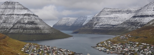
Hotels at Kvívík Hotels at Kvívík booking.com
Travel guide Kvívík

west Haldórsvík faroe-islands north Leynar faroe-islands Kunoy faroe-islands nearest Stykkið faroe-islands Lamba faroe-islands south Kollafjørður faroe-islands east Ljósá faroe-islands
Powered by GetYourGuide


Kvívík

General information - Location

CountryFaroe Islands
Location in countryCenter
Location in Europe North Europe
Coordinates (WGS84)Long: -7.077,Lat: 62.1225 marker
Elevation64 meter above sea level
Local time13:27:08pm
At islandStreymoy
Name province/region (Sysler)Streymoy
Wiki-website Kommuna (Kommuna)Kvívík

Nearest 5 places
Placename Distance Direction
1 Stykkið1.3 km SouthEast
2 Leynar1.9 km EastSouthEast
3 Skælingur4.7 km SouthEast
4 Válur5.1 km NorthWest
5 Vestmanna5.7 km NorthWest

Nearest 3 capitals
Capitalname Country Distance Direction
1 TórshavnFaroe-islands20 km SouthEast
2 Glasgow   Scotland723 km South
3 Reykjavík   Iceland771 km NorthWest

Characteristics - Physical Geography

Kvívík lies at the Atlantic Ocean (direction South). The nearest bigger lake is Søvagsvatn (3.2 km2 at a distance of 10.7 km in WestSouthWestern direction).


Elevation around place: very low location (near sea level): 4%, low location: 52%, hill: 44%, The hills are mainly flatern orientated.
Nearby scheduled flights are operated from (national) airport Bergen Airport, Flesland (at a distance of 689 km and direction EastSouthEast).The closest smaller (subnational) airport is Vágar Airport (at a distance of 12 km in WestSouthWestern direction).

Climate - Temperature and Precipitation


Location of Kvívík in country Faroe-islands


Kvívík at Physical map (height map)

Height map of Kvívík Faroe Islands Location marker for Kvívík

© GTOPO30 DEM courtesy of the U.S. Geological Survey


Tourist information - Travel Guide

Nearest 3 UNESCO-sites
Name Country Distance Direction
1 Heart of Neolithic OrkneyUnited Kingdom of Great Britain and Northern Ireland406 km SouthSouthEast
2 St KildaUnited Kingdom of Great Britain and Northern Ireland489 km SouthSouthWest
3 Vatnajökull National Park - Dynamic Nature of Fire and IceIceland556 km NorthWest


Social media - Maps

Youtube filmpje van KvívíkVideo's op youtube van Kvívík
Vimeo KvívíkVideo's op Vimeo
TikTok KvívíkTikTok
Instagram KvívíkInstagram
flickr foto's en afbeeldingen van KvívíkFlickr
IMDB Kvívík Filming Location IMDB Kvívík
TikTok KvívíkTikTok
Bings mapsBings maps
MapquestMapquest
WikimapiaWikimapia
OpenStreetMapOpenStreetMap

Relief: Altitude classes in percent (within 5km)


Relief: slope classes in percent (within 5km)


Current weather at Streymoy region

Type of weather in Streymoy regionovercast clouds weericoon
Current temperature: 9 degrees Celcius
Rain last 3 hours : No precipitation
Wind: 5.14 mtr/sec (windforce - bft 3)
Wind direction: West
Air pressure: 1032 mb
Humidity: 87 %
Daylength at 17 October 2026:9 hour and 52 minutes
Sunrise :09:17 Europe/Amsterdam
Sunset :19:09 Europe/Amsterdam

Weather coming 24 hours

Streymoy region - FO (longitude: -7.077, latitude: 62.1225)
Distance weather station to place (direction