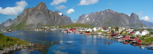
 Sørvågen
 |
|||||||||||||||||||||||||||||||||||||||||||||||||||||||||||||||||||||||||||||||||||||||||||||||||||||||||||||||||||||||
|
|
Booking.com | ||||||||||||||||||||||||||||||||||||||||||||||||||||||||||||||||||||||||||||||||||||||||||||||||||||||||||||||||||||||
SørvågenGeneral information - Location
Nearest 5 places
Nearest 3 capitals
Characteristics - Physical GeographySørvågen lies at the Norwegian Sea (direction South).The place is situated in the rivercatchment named Nordland. The nearest bigger lake is Heggmovatnet (9.4 km2 at a height of around 130 meter above sea level) at a distance of 99.2 km in EastSouthEastern direction).The place is located at an island named Moskenesøya. The distance to the mainland is 69.2 km.The nearest mountain is Hermannsdalstinden with a height of 1029 meter (at a distance of 6.7 km and direction NorthNorthWest). The most nearby international border is the Swedish-Norwegian border with a straight distance of 140.7 km in EastSouthEastern direction. The estimated travel distance is around 197 km. Elevation around place: very low location (near sea level): 4%, low location: 33%, hill: 46%, low mountains: 16%, The hills are mainly flatern orientated. The most common land use in the area is nature. Name area (subregions, nature area, hills, mountains, landscape)
Nearby scheduled flights are operated from (national) airport Tromsø Airport, Langnes (at a distance of 310 km and direction NorthEast).The closest smaller (subnational) airport is Leknes Airport (at a distance of 38 km in NorthEastern direction). Landscape - Landuse (within 5km)
Climate - Temperature and Precipitation |
Location of Sørvågen in country Norway
Sørvågen at Physical map (height map)Tourist information - Travel GuideNearest 3 UNESCO-sites
Social media - Maps
|
||||||||||||||||||||||||||||||||||||||||||||||||||||||||||||||||||||||||||||||||||||||||||||||||||||||||||||||||||||||
Relief: Altitude classes in percent (within 5km)Relief: slope classes in percent (within 5km) |
Current weather at Reine
Weather coming 24 hoursReine - NO (longitude: 13.0153, latitude: 67.8896)Distance weather station to place (direction ZZW): 0 Kilometers
|
||||||||||||||||||||||||||||||||||||||||||||||||||||||||||||||||||||||||||||||||||||||||||||||||||||||||||||||||||||||
5 days Weather forecast: Temperature - Pressure and PrecipitationPressure (mbar)
Wind speed (km/h)
hours
Cloud cover %
precipitation (mm)
hours
|
|||||||||||||||||||||||||||||||||||||||||||||||||||||||||||||||||||||||||||||||||||||||||||||||||||||||||||||||||||||||
|
Widget is loading comments...
|
|||||||||||||||||||||||||||||||||||||||||||||||||||||||||||||||||||||||||||||||||||||||||||||||||||||||||||||||||||||||
| number of views: 222 | |||||||||||||||||||||||||||||||||||||||||||||||||||||||||||||||||||||||||||||||||||||||||||||||||||||||||||||||||||||||


 ©
© 


 Filming Location


