 Ajstrup
 |
|||||||||||||||||||||||||||||||||||||||||||||||||||||||||||||||||||||||||||||||||||||||||||||||||||||||||||||||||||||||
|
|
Booking.com | ||||||||||||||||||||||||||||||||||||||||||||||||||||||||||||||||||||||||||||||||||||||||||||||||||||||||||||||||||||||
AjstrupGeneral information - LocationNearest 5 places
Nearest 3 capitals
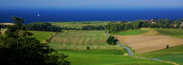
Characteristics - Physical GeographyAjstrup lies at the Kattegat (direction NorthEast).The place is situated in the rivercatchment named Jutland and Funen. The nearest bigger lake is Madum Sø (1.9 km2 at a distance of 18 km in NorthWestern direction).The nearest mountain is Tinghøj with a height of 112 meter (at a distance of 17.6 km and direction West). The most nearby international border is the Danish-German border with a straight distance of 210.5 km in SouthSouthWestern direction. The estimated travel distance is around 295 km. Elevation around place: very low location (near sea level): 32%, low location: 68%, The hills are mainly northern orientated. The most common land use in the area is agriculture. Nearby scheduled flights are operated from (national) airport Billund Airport (at a distance of 123 km and direction SouthSouthWest).The closest smaller (subnational) airport is Aalborg Airport (at a distance of 49 km in NorthNorthWestern direction). Landscape - Landuse (within 5km)
Climate - Temperature and Precipitation |
Location of Ajstrup in country Denmark
Ajstrup at Physical map (height map)Tourist information - Travel GuideNearest 3 UNESCO-sites
Nearest Natura2000-area
Social media - Maps
|
||||||||||||||||||||||||||||||||||||||||||||||||||||||||||||||||||||||||||||||||||||||||||||||||||||||||||||||||||||||
Relief: Altitude classes in percent (within 5km)Relief: slope classes in percent (within 5km) |
Current weather at Hadsund
Weather coming 24 hoursHadsund - DK (longitude: 10.1615, latitude: 56.6862)Distance weather station to place (direction ZO): 0 Kilometers
|
||||||||||||||||||||||||||||||||||||||||||||||||||||||||||||||||||||||||||||||||||||||||||||||||||||||||||||||||||||||
5 days Weather forecast: Temperature - Pressure and PrecipitationPressure (mbar)
Wind speed (km/h)
hours
Cloud cover %
precipitation (mm)
hours
|
|||||||||||||||||||||||||||||||||||||||||||||||||||||||||||||||||||||||||||||||||||||||||||||||||||||||||||||||||||||||
|
Widget is loading comments...
|
|||||||||||||||||||||||||||||||||||||||||||||||||||||||||||||||||||||||||||||||||||||||||||||||||||||||||||||||||||||||
| number of views: 145 | |||||||||||||||||||||||||||||||||||||||||||||||||||||||||||||||||||||||||||||||||||||||||||||||||||||||||||||||||||||||


 ©
© 


 Filming Location


